Autonomous GPS - no correction. +/- 10 meter
Differential GPS
-real-time- Radio Beacon / SBAS / Post-processing
Monday, December 3, 2007

Tuesday, November 27, 2007
GPS data collection with Trimble TerraSync and the GeoXT
Last class we created a data dictionary to use during our field data collection. Allen Instruments has a great operational instruction document for the GeoXT and TerraSync. It is short and to the point. It should not be used instead of the Trimble TerraSync Operation Guide by it is a great field guide. See the Trimble TerraSync Operation Guide for more in-depth instructions.
Monday, November 5, 2007
Lab Quiz
Wednesday, November 7th, 2007
To successfully complete the lab quiz, you will need to do the following at a minimum.
To successfully complete the lab quiz, you will need to do the following at a minimum.
- Create a file-based geodatabase
- Import a CAD feature class into the geodatabase
- Create a new feature class in the geodatabase
- Add and/or delete fields from the above feature classes
- Add domains (range and coded valule) to the geodatabase
- Apply domains and defaults to the feature class fields
- Create features by editing in ArcMap
Subtypes and domains
- Create a sidewalks feature class. Polygon / import spatial reference from other campus data.
- Add fields for Width (integer), Material (Integer), and Condition (Text)
- Add coded value domains to the geodatabase - Width (2,4,6), Material ( 1= Concrete, 2 = Asphault, 3 = Gravel). Condition (Good, Fair, Poor)
- Apply domains to fields
- Create subtype for Material - Default concrete
- Apply default values and domains to subtypes (Concrete- condition = Good, width = 4)(Asphault- condition = Fair, width = 4)(Gravel- condition = Poor, width = 2)
- Go into ArcMap, add sidewalks and start editing. Notice the functionality subtypes and domains give to the editing process.
Monday, October 29, 2007
Domains and more
class Thursday, October 25th, 2007
Demonstrate editing techniques - cutting polygons and auto-complete
Add new fields to building layer to store building floors and height
Adding values to attribute tables
Create range domain on floors field (1-5)
Validating range domains
Demonstrate editing techniques - cutting polygons and auto-complete
Add new fields to building layer to store building floors and height
Adding values to attribute tables
Create range domain on floors field (1-5)
Validating range domains
Tuesday, October 16, 2007
More campus ...

Building polylines or polygons? Yeah, you guessed it -polygons. So, how do we go from the CAD polylines to polygons?
A great tool available at the Arc/Info license called Feature to Polygon. Check it out the screen shot.
Another great tool, if you did not have Arc/Info is an extension for the software called XTools Pro.
It has a lot of great free functionality but if you plan to use it past the evaluation period you'll need to buy it. This extension has all kinds of feature conversions, table operations, layer operations and more. Check it out!
Monday, October 15, 2007
Utilize the feature class created from CAD import to parsing out individual layers
Last class, we imported a CAD polyline feature class of the campus to a single feature class in our campus geodatabase. We also georeferenced this new feature class to real-world coordinates using the Spatial Adjust toolbar.
This new feature class had many different features of the campus like buildings, sidewalks, utility poles and other important data. These features can delineated based on the 'layer' they were on in the CAD file. This information is brought over to the GIS in a field called 'layer'.
This class, we will use the georeferenced data that we imported from CAD to a single feature class to parse out into individual features classes.
HOW?
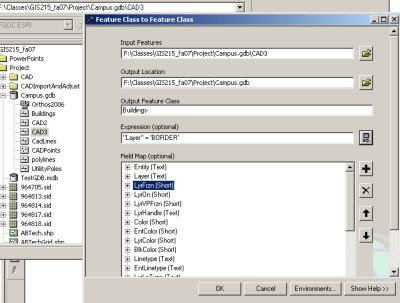
Utilize ArcCatalog to EXPORT layers. During the export using the query tool to select a subset of features to be exported to the new feature class. This will allow you to segregate features from individual CAD layer and export them to feature classes.
You should end up with individual feature classes in your geodatabase for buildings, sidewalks, utility poles, etc...
See graphic below for an example of how the dialog box should look for exporting the features from the buildings layer to a new Buildings feature class in the same geodatabase.
This new feature class had many different features of the campus like buildings, sidewalks, utility poles and other important data. These features can delineated based on the 'layer' they were on in the CAD file. This information is brought over to the GIS in a field called 'layer'.
This class, we will use the georeferenced data that we imported from CAD to a single feature class to parse out into individual features classes.
HOW?
Utilize ArcCatalog to EXPORT layers. During the export using the query tool to select a subset of features to be exported to the new feature class. This will allow you to segregate features from individual CAD layer and export them to feature classes.
You should end up with individual feature classes in your geodatabase for buildings, sidewalks, utility poles, etc...
See graphic below for an example of how the dialog box should look for exporting the features from the buildings layer to a new Buildings feature class in the same geodatabase.

Subscribe to:
Posts (Atom)
